


No products in the cart.
Return To Shop
A Rila Mountains self-guided hut-to-hut trek
We’ll offer you a comprehensive guide about the Rila Traverse – a 7-day long trek that covers the most interesting parts of these mountains. Of course, in order to complete the trek independently, you need to be comfortable in navigating yourself in unknown mountains even in poor weather conditions – possible during the peak summer season also. To work confidently with a map and a compass. In the best scenario you’ll follow the well marked trails for a week without any problems, in the worst – you may get lost and need assistance form the local mountain rescue teams (112). Thats why, along with the proper equipment, you need to supply yourself with a valid insurance and have a mobile phone with you. For a relevant map of the area and a GPS map to download, please check the Maps section of our website. Read more about the self guided trips in Bulgaria we offer.
Why Rila Mountains?
- They are quite close to the capital Sofia – the main starting points at Borovets, Malyovitsa and Panichishte are only 1,15-1,5 hours drive from the city;
- Rila is the highest mountain on the Balkans with Mount Musala (2925 m);
- Rila Mountains host the biggest of the three national parks in Bulgaria – Rila National Park;
- Rila offers dramatic landscapes – glacial lakes, jagged peaks, old conifer forests and alpine meadows;
- Rila has unique flora and fauna – endemic and relict species and endangered animals like the Brown Bear, the Imperial Eagle, centuries old forests;
- There is a wide network of well marked tourist trails along with huts to stay for the night for a reasonable price;
- Learn more about Rila Mountains.

The sign of Rila National Park
The most popular sights in these mountains are located in Central Rila – Mount Musala and in Northwestern Rila – Malyovitsa, The Seven Rila Lakes, Rila Monastery, Skakavitsa Waterfall. Check “Rila Mountains” section of the website for more info.
Best time to visit is between June and October, although in June you may expect dangerous snow drifts on some of the trails and in October you may have quite low temperatures during the night and even snowfalls are more possible. Both in June and October there is a bigger chance of rainy weather. July and August are the driest months but also most people visit during this time.
The trails are marked well in general, in white and coloured strips and parallel iron posts on some routes. Read our article about the markings here.
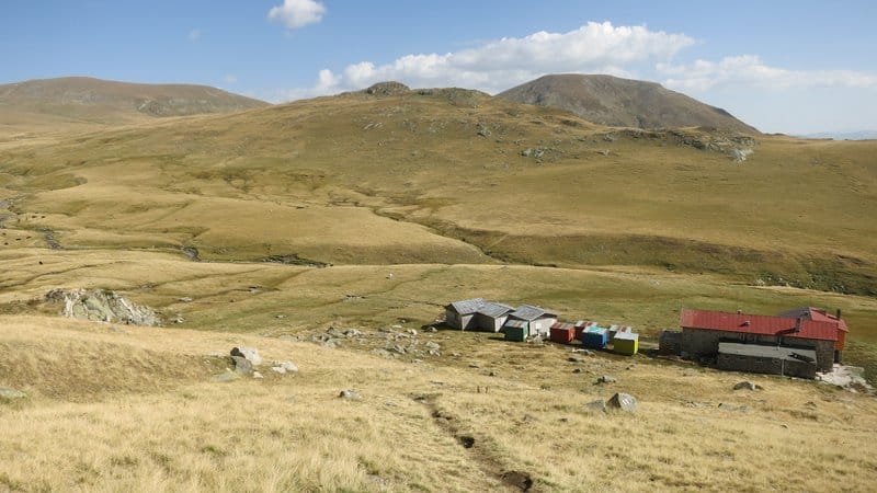
The accommodation is basic – dormitories, no shower at most places – but all of the huts would offer you a warm meal, so you’ll not need to carry something more than a day snacks and a travel liner. More info about the huts network. Camping is forbidden within the territory of the national park, so better leave the tent at home.
Here is the itinerary itself:
Day 1: Sofia – Borovets – the gondola lift up to Yastrebets Hut – Musala Hut (- Ledeno Ezero Hut, +1,15 hours);
Day 2: Musala Hut (or Ledeno Ezero Hut) – Mount Musala – Granchar Hut;
Day 3: Granchar Hut – Ribni Ezera Hut;
Day 4: Ribni Ezera Hut – Kirilova Polyana – Rila Monastery;
Day 5: Rila Monastery- Ivan Vazov Hut;
Day 6: Ivan Vazov Hut – Malyovitsa Hut via Mount Malyovitsa;
Day 7: Malyovitsa Hut – the parking lot of Malyovitsa – Sofia.
In order to visit the famous Seven Rila Lakes you may stay at Ivan Vazov Hut for a second night and do a circular walk around the lakes and back to the hut.
>>Read the day by day description here>>

Related posts

How to get to the Bulgarian UNESCO site Rila Monastery by public transport from Sofia. Continue reading

There is a lot of resources covering the general safety issues in the mountains and we’ll discuss only some aspects of them that might be... Continue reading

The European Ramblers Association (ERA) has developed a network of 12 long distance walking paths that cross most of the European countries. Following any of... Continue reading

2023 up to date information on the working hours and operating schedule of the main lifts of Rila, Pirin, Vitosha and Balkan mountains in Bulgaria.... Continue reading

The city of Plovdiv is the second biggest city of Bulgaria with population of about 350 000 inhabitants. It is located in the central parts of the... Continue reading

31 comments
Philip
Hi, I’m looking at spending a few days next year and I see in your description of the stages that you say Musala hut – not recommended. Why is that? Surely it’s OK to stay there.
Thanks
Philip
Lyuben GrancharovAuthor
Thanks for pointing out that. By the time of writing this description the hut was quite poorly maintained. The conditions are still basic, but what I hear is the new hosts are now making improvements and are more welcoming to visitors.
Lea
Hey,
Is it possible to plant the tent near the huts?
Thank you very much
Lyuben GrancharovAuthor
Hi, yes, this is no problem, just ask at the huts.
Lea
Thank you very much for your answer:)
Alex
Will the huts be open in April ? We are experienced in winter mountaineering and are interested in doing some sections of this itinerary ?
Thank you
Alex
Lene Jespersen
Hi there,
does anybody know if the huts for the Rila Traverse itinerary as listed above are still open next week (until the 21st of october)? I have tried to call and write without luck.
Thanks!
Lene
Natacha
Dear, is it recommended to do the trek during the week of the 10th October with a tent? Will it be below 5degrees at night? Is it normally wet during that period?
Lyuben GrancharovAuthor
Probably around/below 0 at night, temperatures vary in this period.
Lene Jespersen
Hi there,
does anybody know if the huts for the Rila Traverse itinerary as listed above are still open next week (until the 21st of october)? I have tried to call and write without luck.
Thanks!
Lene
Jakub
Hello!
I plan on trying the Rila Traverse during the first half of October. Have there been any major changes in the huts organization due to the pandemic, or do they operate normally?
Jakub
Lyuben GrancharovAuthor
Hello Jakub, the huts operate as usual, but better call the more isolated ones if you visit during week days.
Jakub
Thank you Lyuben, I will definitely do that. Would you happen to know whats the fastest way to get from the Sofia Airport to the South Bus Station to catch the bus to Borovets? My plane lands around 12 and I would like to make it to Musala Hut on the same day. Again, thank you very much for your answer and the detailed guide 🙂
Lyuben GrancharovAuthor
You can get metro from the airport directly to Joliot Curie metro station which next to the Bus station: https://goo.gl/maps/bZXWampc2WyuYWrp8
Fanette
Hello,
First thank you very much for this website and all your advises. It is very helpful!!
I plan to go to Bulgaria from 30th May until 10th June and I would like to hike in Rila Moutains (aroind 7 lakes) for 3-4 days.
Do you think it is possible in this time of the year and if the hut are open?
Do you suggest me to plan my hiking in the begining or at the end of my stay in Bulgaria (5-10 June)?
Thanks in advance for your answer?
Fanette
Lyuben GrancharovAuthor
Hello Fanette, May-June is a bit early for these routes as you`ll encounter some snow here and there. Crossing it could be between anointing and quite dangerous depending on the terrain. The huts are open and it is a very nice period to visit, but you need to adjust your route given the conditions. You may also plan on the Rhodopes where the snow will be completely gone by this time. More info on the spring conditions: https://bulguides.com/spring-hiking-in-the-mountains-of-bulgaria/
Claudia
If any woman is planning to stay in Ribni Ezera Hut, you should know this. I was there last night and the man working there was extremely disgusting. At first I was planning to stay there by myself as I was doing a 3 day hike. My bulgarian friend called and booked a bed. When I got there the man was staring at me weridly all the time, trying to get closer to me and flirting with me. It was so intimidating. Luckily I met a hiker on the way and he stayed with me in the hut. I wouldn’t have liked to be there by myself.
david
Hi!
Me and two friends want to do a similar route, I have one question to you:
Is it possible to get to Ribni Ezera Hut from the Scary Lake?
Lyuben GrancharovAuthor
Yes, Scary Lake – Kobilino Branishte – Vodnia Chal ridge – Ribni Lakes
Bozena
Hello,
Is it possible to do this trek in early May?
Lyuben GrancharovAuthor
There is still too much snow: https://bulguides.com/skylab1/spring-hiking-in-the-mountains-of-bulgaria/
Dror
Hi there,
Is there an option to walk a part of the itinerary?
How difficult would it be for a healthy 20 year old with no experience of long hikes?
Does the itinerary include the seven lakes?
Thank you very much,
Dror
Lyuben GrancharovAuthor
It doesn`t include the 7 lakes, but you can extend it and climb up to the lakes after the monastery. If you have no experience you need to prepare well in terms of navigation, weather and terrain judgment and best is to get someone for a company. It could be fine to complete it but also in certain conditions you may get into trouble. If you get a map you`ll see where you can escape the route and go down the mountain, if you want to do only a part of it.
Gal
Is this possible in october ? if not, setpember? Do you have a good map for hiking and is it available for purchase?
Lyuben GrancharovAuthor
Yes, it is possible both in October and September, but is more weather dependent, more info here: https://bulguides.com/skylab1/walking-trekking-in-bulgaria-in-autumn/
You can check the available maps here (Rila East and Rila West 1:25 000 or Rila 1:50 000): https://bulguides.com/skylab1/maps/
Floor
Hi!
I am planning on following this hiking itinerary. As the route ends at the parking lot of Malyovitsa, but I don’t have a car so I will be travelling with public transport. Is that possible from Malyovitsa? Are there busstops in the (surrounding) area?
Thank you!
Lyuben GrancharovAuthor
Yes, there are shuttles: https://bulguides.com/skylab1/how-to-get-to-malyovitsa-by-bus/
Floor
Thank you so much and sorry I didn’t read well enough. It was already on your website.
One question left: I want to include the 7 Rila Lakes to the itinerary too but I don’t have many spare days left. Is it possible to for example walk from the Ivan Vazov Hut to the Lovna Hut and from the Lovna Hut to the Malyovitsa Hut and end there. Or would you advise something else?
Lyuben GrancharovAuthor
Yes, you could do this, even for 1 day you could pass by the lakes and reach Malyovitsa via Vada Hut.
Matej Hruby
Hi!
I would like to ask you for advice. In the middle of June I’m going to Rila and Pirin mountains. I would like consult with you my itinerary. I would like to start at the early morning at the Borovest and across Musala will go to the Ribini lakes hut (aprox. 35 km per day). Second day to the Rila monastery and also sleep there (26 km per day). Third day will continue to the Makedonia hut (25 km per day). Fourth day to the Javorov (40 km per day). Fifth day to the hut Horskij raj or Pirin (40 km per day). And the sixth day to Melnik town and continue by public transport to the Sandanski and then by train to the Thessaloniki.
Is possible to sleep in the tent in an area around huts? And is any website where is possible to book accommodation? I would like also ask you about food and water. Is there some opportunity to buy some food and water in that huts? (I walking really lot of, so I have not problem with distance about 40 km per day)
I will be very grateful for your opinion and your advice.
Thank you very much
Matej
Lyuben GrancharovAuthor
Hello Matej, the day stretches you plan are far above average, especially the Pirin part. In June problematic might be snow drifts on some of the trails, that could be dangerous, also possibly more unstable weather. A couple of the stretches are difficult to navigate as not marked well. Would say the route is maybe possible if you are very well equipped, very well trained, experienced in navigation and dealing in more difficult and possibly dangerous terrain, also lucky with the weather. There is no website to book the huts unfortunately, you need to contact them directly. Food is offered in all the places. Camping next to the huts is fine. Water is not a problem on the way, except along the main ridge of Pirin.